



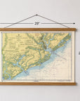


Charleston to Edisto, South Carolina Nautical Chart Canvas Wall Scroll
Celebrate one of America’s most historic sailing destinations with this Charleston to Edisto, South Carolina nautical chart canvas wall scroll.
Featuring the waters surrounding Charleston Harbor and the South Carolina Lowcountry, this detailed nautical chart captures the coastline, rivers and islands that make this stretch of coast such an iconic maritime destination. From Charleston Harbor, the Wando and Cooper Rivers to James Island, Johns Island, Kiawah Island, the Otter Islands and Edisto Island, it’s a beautiful reminder of time spent boating, sailing and exploring the Lowcountry.
Printed on canvas and finished with wooden hanging rails, the chart has the character of a vintage maritime map with a relaxed, coastal feel that works beautifully in a beach house, boat, office or home.
DETAILS
- Made to order, ships in about two weeks from Fall River, MA
- Detailed Charleston to Edisto, South Carolina nautical chart
- Features Charleston Harbor, the Wando and Cooper Rivers and the surrounding Lowcountry waterways
- Includes James Island, Johns Island, Kiawah Island, the Otter Islands and Edisto Island
- Printed on durable canvas
- Finished with wooden hanging rails
- Ready to hang
- A great gift for sailors, boaters, Charleston homeowners and Lowcountry lovers
- Made in the USA
Whether Charleston and the Lowcountry are home, your favorite harbor, or simply the best place on earth, this nautical chart scroll turns a place you love into a piece of art.
Made to order, ships in about two weeks from Fall River, MA.


