
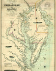




Antique Chesapeake Bay Civil War Era Map Canvas Wall Scroll
Explore the Chesapeake as it appeared during one of the most consequential periods in American history with this antique Civil War era Chesapeake Bay map canvas wall scroll.
Featuring a beautifully detailed historic chart of the Chesapeake and Delaware Bays, this map captures the intricate coastline, rivers, harbors and waterways of the Mid-Atlantic during the Civil War era. From Maryland through Virginia and the mouth of the Chesapeake, it is both a striking piece of cartographic art and a fascinating glimpse into 19th-century America.
Printed on canvas and finished with wooden hanging rails, the map has the character of an antique chart while arriving ready to hang—no traditional framing required.
Perfect for history enthusiasts, sailors, Chesapeake Bay residents and collectors of antique maps, this wall scroll brings together American history, nautical heritage and vintage cartography in one distinctive piece.
DETAILS
- Ships in 5 days from Fall River, MA
- Antique Civil War era Chesapeake Bay map
- Features the Chesapeake and Delaware Bays
- Historic Maryland and Virginia nautical chart artwork
- Printed on canvas
- Finished with wooden hanging rails
- Ready-to-hang wall scroll design
- Measures approximately 20.5" wide x 29" high
- Great for coastal homes, offices, libraries and history-inspired interiors
- Designed and produced by Maritime Tribes
A MAP OF A PLACE THAT MATTERS
The Chesapeake Bay has shaped American history for centuries—from commerce and sailing to the events of the Civil War. This historic canvas wall scroll celebrates that remarkable maritime heritage while creating a beautiful connection to one of America’s great waterways.
Ships in 5 days from Fall River, MA