



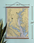


Annapolis, Chesapeake Bay Northern Part Nautical Chart Fabric Scroll
Bring the beauty of the Chesapeake Bay into your home with this vintage Annapolis and Northern Chesapeake Bay nautical chart canvas wall scroll.
Featuring a detailed nautical chart of the Chesapeake Bay and Maryland’s Eastern Shore, this map captures one of America’s most celebrated sailing regions. From Annapolis and the Severn River across the Bay to Kent Island, St. Michaels, Rock Hall, the Chester River and Eastern Bay, the chart is filled with the harbors, rivers, islands and waterways that make the Chesapeake such an extraordinary place to explore by boat.
Printed on canvas and finished with wooden hanging rails, the map has the character of a vintage maritime chart with a relaxed presentation that works beautifully in a coastal home, boat house, office or sailing-inspired space.
It also makes a distinctive gift for sailors, boaters, Chesapeake Bay lovers, Annapolis residents and anyone with a special connection to Maryland’s Eastern Shore.
DETAILS
- Ships in 5 days from Fall River, MA
- Vintage nautical chart of Annapolis & the Northern Chesapeake Bay
- Features Annapolis, St. Michaels, Rock Hall, Kent Island, Eastern Bay, Chester River and Maryland’s Eastern Shore
- Printed on canvas
- Finished with wooden hanging rails
- Ready to hang
- Approximately 20.5" wide x 29" high
- A great gift for sailors, boaters and Chesapeake Bay lovers
- Made in Fall River, Massachusetts
Whether your favorite Chesapeake destination is Annapolis, St. Michaels, Rock Hall or somewhere along Maryland’s Eastern Shore, this vintage nautical chart is a beautiful way to keep the Bay close to home.
Ships in 5 days from Fall River, MA


